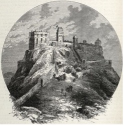
Apr 132024
 

Linkfield Rd, Musselburgh, EH21 7RG

undefined
Source: Thomas Nugent

The Mussleburgh Racecourse is the second largest in Scotland and has been active since at least 1777, when opened as part of the Royal Caledonian Hunt. The course is 2km long and hosts both flat racing and National Hunt meetings. Quite uniquely, in the middle of the loop, there is the nine-holes Musselburgh Links golf course, dating from at least 1672, and home to the Royal Musselburgh Golf Club established in 1774. Attracting tens of thousands of visitors per year, the Musselburgh Racecourse is home to some of the premier fixtures of the Scottish sports calendar.

Horses making way to start line at Musselburgh racecourse, picture via flickr theedinburghblog

Musselburgh Racecourse https://www.musselburgh-racecourse.co.uk/

Apr 132024
 

Morrisons Haven, Prestonpans, EH32 9RX

File:Prestongrange Museum (9741608889).jpg
Source: marsupium photography

Prestongrange was a key industrial area for hundreds of years. The busy activity included harbour, glass works, pottery, colliery and brickworks. Whilst the workshops and factories have now disappeared, the industrial landscape remains, including a large winding gear, a vast brick kiln and a Cornish beam engine. Thus, following the closure of the Prestongrange coal mine in 1962 (spanning in total over 700 years of coal mining in the area), the site was transformed into an open-air museum with a dedicated Visitor Centre.

Visitors can experience the hubbub of industry that was Prestongrange, from the the first deep shaft in Scotland, which Matthias Dunn of Newcastle sank in 1830 to the Great Seam at 420 feet (128 m), and right to the end of the coal power in the area with the decommissioning of the Cockenzie Power Station in 2013 and the demolition of its two iconic 149m-tall chimney stacks. The ash lagoons created by the power station span the coastline towards Musselburgh, now home to abundant wildlife sheltered by the low woodland.

Video from Out about Sotland via youtube

Prestongrange Museum https://www.eastlothian.gov.uk/info/210593/museums/11878/museums_in_east_lothian/4

Apr 132024
 

W Harbour Rd, Cockenzie, Prestonpans, EH32 0HX

The 1722 Waggonway Project - History Scotland
Source: Ed Bethune, FSA Scot

Scotland’s first ever railway was built in 1722 connecting the harbour at Cockenzie with the nearby market town of Tranent, where coal was being mined. This followed a route used by a more simple wooden track since the 16th century. Alongside the fascinating story of the waggonway, the museum tells the history of the local area, especially the salt making, glass manufacturing, coal mining, as well as herring fishing from the Cockenzie and Port Seaton Harbours.

The Cockenzie Harbour is built on the site of a natural harbour, which was designated a free port by James VI in 1591. With excellent port facilities, the trade with Flanders, in the present day Belgium, and France was particularly strong. Today, the harbour is home to a small fleet of fishing vessels and pleasure crafts.

Cockenzie History http://www2.thesetonfamily.com:8080/gallery/Cockenzie_House_History.htm
1722 Wagonway Museum https://www.1722waggonway.co.uk/museum

Apr 132024
 

Aberlady Bay Car Park, Longniddry, EH32 0QB

File:Remains of Miniature Submarine. - geograph.org.uk - 201385.jpg
Source: DD

Along the coastal path connecting Aberlady with North Berwick, one can see many curiosities including the wreck of two World War II X-type midget submarines in Aberlady Bay.  These vessels were about 16 metres (52 ft) long, only big enough for a crew of four: a commander, a pilot, an engineer and a specialist diver. They were powered by a diesel engine when on the surface and an electric motor when underwater. These midget submarines were exclusively used for special coastal operations, for instance the 1943 raid on the German battleship Tirpitz in a Norwegian fjord and as guide boats for the 1944 Normandy landings.

The two submarine skeletons in Aberlady Bay were exclusively used for training, firstly as part of preparing for missions, as well as targeting research and for anti-submarine areal defence. It was as part of this latter use that they were towed and moored in the shallow waters near Aberlady, so they could be part of trials launched form the nearby East Fortune airfield.

3D reconstruction of the submarines from Wessex Archeology via the Society for Nautical Research, where you can also listen to a podcast on the reconstruction project

Midget Submarines in Aberlady Bay https://awesomeaberlady.com/aberlady-bay-midget-submarines/

Apr 132024
 

School Rd, North Berwick, EH39 4JU

Who We are — Coastal Communities Museum
Source: East Lothian Council

The Coastal Communities Museum is home to a varied set of collections and exhibitions, exploring and recounting the past and present life of the coastal communities in the North Berwick coastal ward. Local history starts 400 million years ago, when in a dramatic way the nearby extinct volcano, now a grass covered hill, the Law, was formed. North Berwick was a critical centre and port throughout the history, as it was the quickest way to connect the South East of Scotland with Fife peninsula to the North. Critically important was the ferry route to St Andrews, a major pilgrimage destination in medieval times.

More recently, the beautiful sandy beaches to the West and stunning cliffs to the South-East have been attracting numerous visitors to the town, especially since the construction of the railway line in the mid-19th century. North Berwick is also known as one of the earliest and premier centres for golf, having had established golfing groups since 18th century and one of the world’s oldest official golf clubs, formed in 1832.

Coastal Communities Museum  https://www.coastalmuseum.org/
History of Golf in North Berwick http://www.northberwick.org.uk/origins.html

Apr 132024
 

Tantallon, EH39 5PN

File:Tantallon Castle (13893797521).jpg - Wikimedia Commons
Source: marsupium photography

Tantallon Castle’s ruins sit on top of a sea cliff opposite the Bass Rock, and represent the last curtain castle constructed in Scotland, dating from mid-14th century. The castle’s dominant “curtain wall” is made from distinct red sandstone and spans over 15 metres (49 ft) high, 3.6 metres (12 ft) thick, and around 90 metres (300 ft) long, with ruined towers on each side. The castle was besieged, attacked and damaged through some of the decisive moments in Scottish history, from the Bishop’s Wars to the 1651 Cromwell’s invasion, the latter leaving it ruined. Since, the castle has been quarried for stone, inspired a number of artworks, and served in training exercises in World War II to the nearby East Fortune airfield, which is now the National Museum of Flight. Tantallon is open to visitors, managed by the Historic Environment Scotland.

Visit the doocot which might be the best preserved part of the castle
View from the castle towards Bass rock, picture from Historic Scotland

Tantallon Castle https://www.historicenvironment.scot/visit-a-place/places/tantallon-castle/

Apr 132024
 

Castle Gate, Dunbar, EH42 1HX

Robert Wilson (1803 - 1882) - John Gray Centre

A black painted ship propeller opposite Victoria Harbour has been unveiled in 2003 as a memorial to a Dubar-born maritime inventor, Robert Wilson, on the occasion of the 200th anniversary of his birth. Robert Wilson was born at the Shore of Dunbar, following the death of his father, difficult circumstances meant the family moved inland. However, Wilson’s passion for the sea and ships remained strong and he worked on maritime propulsion since his teenage years, supported by the Lauderdales in Dunbar.

By the 1820s, he demonstrated working models of rotary propellers in Leith Harbour, and winning a prize from Highland Society and the Scottish Society of Arts in 1832.  As his inventions were not widely adopted yet, he earned his living as Works Manager of the Bridgewater Foundry (in Patricroft, Lancaster) later becoming the managing partner. Wilson secured over 30 patents for engineering advances, both for the technology behind Nasmyth’s steam hammers, as well as some in propellers. While he did not receive the wide recognition – Francis Petit Smith reaped most of the rewards – his work was accepted by the navy and in 1880 he was awarded 500 pounds to licence his double action screw propeller to drive torpedoes.

Robert Wilson: https://www.johngraycentre.org/people/engineers-and-inventors/robert-wilson-1803-1882/

Apr 132024
 

Dunbar, EH42 1HY

File:Piles of Coloured Creels at Victoria Harbour Dunbar (geograph  5747129).jpg - Wikimedia Commons
Source: Jennifer Petrie

Dunbar Harbour is an important shellfish harbour as well as mooring for pleasure and rowing boats, and was in the past a key maritime commercial hub at the mouth of the Firth of Forth. The Harbour is made up of three distinct parts: The Old Harbour (sometimes called Cromwell Harbour) is dating from 1547 to the East and is protected by a 920ft sea-wall terminating short of Lamar Island, a rocky outcrop which long sheltered the prior natural anchorage. The New or Victoria Harbour in the West dating from 1842; and Broad Haven, the old entryway to from the sea, now sheltered water between the two Harbours. In the past, the harbours here were also protected by one of the strongest fortresses in Scotland, the Dunbar Castle, ruins of which are to the north of Victoria Harbour. 

undefined
Source: Phillip Capper

Dunbar Harbour is also known as the home to the second oldest Royal National Lifeboat Institution (RNLI) station in the UK, constructed in 1901 and continuing a service dating from 1808. The Harbour complex has a number of engineering features such as:  The Ordnance Survey Tidal Gauge built in 1913 as part of a network of stations used to establish the ‘Mean Sea Level’ to measure all land heights in the UK; a 19th century two-leaf bascule bridge that spans from the Victoria Harbours Quay to the Lamar Island; and Dunbar Battery, a built in 1781 on Lamar Island, to protect the town from privateers. The battery’s structures were converted into a hospital for infectious diseases in 1874, though closing in 1906, until being re-opened as a World War I hospital in 1914. More than a century later, in 2017, the battery has been repurposed as an outdoor arts venue.

Dunbar Battery: https://dunbarbattery.org.uk/
Dunbar Harbour Trust: https://dunbarharbourtrust.co.uk/
Dunbar RNLI Station: https://rnli.org/find-my-nearest/lifeboat-stations/dunbar-lifeboat-station

Apr 132024
 

126 High Street, Dunbar, EH42 1JJ

undefined
Source: Kim Traynor 
Historic image with the house on the left, picture from 1842 from book Son of the Wilderness: The Life of John Muir via wikipedia

John Muir, the pioneering naturalist and preservationist, was born on 21 April 1838 in the house at 126 High Street in Dunbar. His family moved to US when he was 11 years old and following eclectic studies at the University of Wisconsin, Muir dedicated his life to exploring, describing and advocating for the protection of wildness. He was instrumental in the protection of the Yosemite National Park in US, as well as other areas of outstanding natural beauty in the American West. He is noted for advancing the “preservationist” principles to wilderness protection, eschewing any human “use” of natural environment, in contrast to the “milder” conservationist movement, where more exploitative activities are permitted, as long as some of the area is preserved.

Picture of John Muir, an older man with a long beard, sitting on a rock at a lake surrounded by pinte trees, staring into the distance with his hat next to him on the rock.
John Muir, picture taken around 1902 from wikipedia

Muir was a prolific writer and published books describing his time in the wild as well as botanical and geological theories. He was well known in his time, and with his “celebrity” status, he spent time in the wild with the US President Theodore Roosevelt as well as scientists, artists and philanthropists. In his honour, his birthplace is now a museum dedicated to interpreting his life and work, and is also the staring point of the John Muir Way, a walking route connecting Scotland’s East and West coast (Dunbar-Helensburgh). The John Muir Country Park, a conservation area dedicated to local coastal flora and fauna is located to the North of Dunbar.

Track of the John Muir Way from the Sierra Club
John Muir Country park, picture from Visit Scotland

John Muir’s Birthplace https://www.jmbt.org.uk/
John Muir’s Way https://johnmuirway.org/

Apr 132024
 

High Street, Dunbar, EH42 1ER

Category:Dunbar Town House - Wikimedia Commons
Source: Kim Traynor

The 16th century Town House on Dunbar’s High Street is one of the oldest buildings and most distinctive buildings in town, with its witch’s hat tower, hosting a clock, a bell and sun dials. Inside, the collection spans portraits of every town provost since 1833, as well as historic heraldic panels and a set of ceremonial robes used by local government past and present. The Town House is also home to Scotland’s oldest functioning council chamber, debates in which included the infamous East Lothian witch trials. There is also a jail with an original iron door and a debtor’s cell, with prisoners’ graffiti in the fireplace.

The Town House Gallery hosts regular thematic exhibitions and Dunbar and District History Society created a local history display within the Town House. In addition to the standing collection, the Society can provide further information from the comprehensive local history archive and research room. The Town House is the centre of the local tourist information service, and there have even been reports of haunting!

The historic Dolphin Inn was recently renovated and its owners are working with Dunbar’s historic society to make a dedicated trail on the history of Dunbar which will follow soon.

Dunbar Town House Museum and Gallery https://www.eastlothian.gov.uk/info/210593/museums/11878/museums_in_east_lothian/3